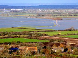
 Mid-Somerset flooding (geograph.org.uk)
 The Levels are not one uniform area, and are broken in to swathes of flat land between hill ridges, from north to south: the Mendips, Poldens, Quantocks and Blackdowns. The worst area for the flooding is happening in mid and south Somerset and for those affected - some of the more remote hamlets and villages in South Somerset - it is no joke after weeks being cut-off (at best) or flooded (at worst).
Luckily and thankfully this is not affecting our area in the north of the county; certainly we can see some flooded pastures around us and some of the rhynes in places are full and almost overflowing small lanes. But this is not at all worrisome. Cheddar itself is on the south scarp of the Mendips and Gorge View house and the cottage are helpfully a little up from the levels which start on the edge of the village. Being on a fertile flat limestone shelf 25m above sea-level certainly makes us feel blessed.
With luck the persistent rain that the whole of the UK has been experiencing will ease up and the flooding will abate soon. In our view this frequency of extremes of weather (wet, dry, hot, cold, windy) is a clear result of the very beginnings of climate change - largely man-made with the extraordinary and growing amounts of carbon we are collectively pumping in to the atmosphere to levels not seen in human times. So it reinforces our efforts to live as lightly on the land as is reasonable and certainly if you come and stay at Gorge View Cottage you are implicitly having a low- (or lower-) carbon vacation.

 RSS Feed
